
Airspace: Who Cares?
|
Getting your Trinity Audio player ready...
|
Once in a while, it happens. An experienced instrument pilot, flying a high-performance airplane with multiple moving maps, ends a trip with an airspace violation. How could that have happened? The flight had been under IFR, so airspace doesn’t matter…until it does. It might not apply directly to every phase of flight when you’re in the system, but we move around quickly up there; it takes mere seconds to be in the wrong place. That’s why good situational awareness, a key element of safe IFR flight, includes airspace awareness.
It Gets Busy
One of the biggest gotchas is a matter of chart design. Beneath and around every complex Class B hub, there are all flavors of airspace crammed in there—but you wouldn’t know it by the IFR en route charts. For example, look at Chicagoland. There are no color-coded rings or symbology to easily see that Chicago Executive (KPWK) is a Class D field with a control tower, where radio communications must be established. Moreover, the chart conceals its western and southeastern edges, joining the Class B floors (which differ on either side).
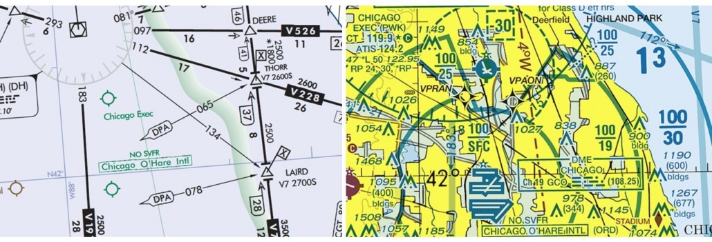
On the en route chart, there are no color-coded rings or symbology to easily see that Chicago Executive (KPWK) is a Class D field.
So what? You’re IFR, so all that’s worked in. True, but you’re much better off knowing what’s around you. If using Runway 16 at KPWK, the missed approach requires a low climb to the left, and departures include a similar low-turn departure instruction. Those are designed specifically to keep you outside the Bravo, and it’s up to you to fly those paths precisely. A delay in the initial turn could result in an airspace breach. How much of a delay? Layering on the airspace borders will show you just how tightly PWK airspace is tucked in there.
Now look to the north of Chicago and find Waukegan and Kenosha. Those are also Class Deltas, stepping stones along a traffic-laden corridor running up the Lake Michigan shoreline. To reveal their true nature, swap to the VFR sectional and see how close the airspaces are. This is a hot spot for both IFR and VFR violations, because aircraft on visual approaches to KENW’s 33 and KUGN’s 14 have maneuvered for long finals and entered the neighboring Delta without communication or coordination.
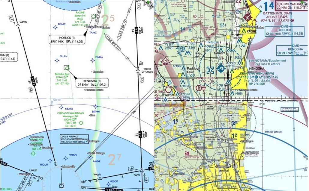
The airspace around Waukegan and Kenosha is a hot spot for both IFR and VFR violations.
Such airport pairings are all over the place, especially under and around Class Bs. Using instrument approach final legs or GPS visual procedures are common tools to fly stabilized approaches, but can potentially cause inadvertent airspace entries. And since visual approaches don’t have missed approach procedures, you’re on your own for navigating for traffic, obstacles, and airspace.
Vectoring can’t always save you either. Small, low-level TFRs can pop up outside ATC’s jurisdiction but on your intended route. Special Use Airspace, such as TFRs—especially those associated with sports venues and stadiums—are often not on ATC’s radar, so to speak.
The Uncontrolled Spaces
It’s common practice to wait until after landing to cancel. This offers less distraction on approach and keeps that protective IFR bubble all the way to the ground—most of the time.
But there can be situations when canceling in the air is a safe option. Take a clear day full of VFR traffic out enjoying the sunshine. You’ve descended in preparation for approach and might need to maneuver laterally or climb/descend to avoid traffic. You won’t have as much flexibility to make quick adjustments while IFR, and Minimum Vectoring Altitudes limit how low ATC can follow you.
Or, on an “IFR” day, VFR traffic can still be flying around in Class G. Remember G? That’s uncontrolled airspace, so ATC can’t assist you—much less hear or see you. While not the safest thing to do, VFR aircraft can legally fly in 1 mile visibility while remaining clear of clouds, and they’re most often found going around the traffic pattern.
Class G airports with IFR approaches have lower Class E layers for some protection; VFR requires three miles’ visibility while at least 500 feet below the clouds. But that’s pretty minimal weather to see in, so if you don’t pay attention to E and G, surprise traffic encounters could be in store.
Not So Fast
For those of you flying faster—like a twin or single turboprop—are you up on speed limits? Yep, that’s airspace-dependent too. See 14 CFR §91.117. That list of rules includes not exceeding 200 knots “at or below 2,500 feet above the surface within 4 nautical miles of the primary airport of a Class C or Class D airspace area…” unless otherwise cleared. The same limit applies to airspace “underlying a Class B airspace area designated for an airport or in a VFR corridor designated through such a Class B airspace area,” while the general limit is 250 knots within a Class B.
Knowing the airspace you’re in and near also keeps you prepared should something else require your attention. Got a “Low Fuel” or “Low Voltage” light? Time to divert and request an amended clearance. True, ATC will provide any information you need, including frequencies. But if you have airspace awareness, you can quickly think ahead and cut down on the radio exchanges, especially when it’s busy.
You can more easily anticipate your workflow, like a handoff to a tower or a change to advisory, often paired with terminating radar services. All good to know.
If it’s not an abnormal situation or emergency, but you want to change the destination, the biggest airspaces aren’t always the best if you want to save fuel on approach or spare yourself a long taxi to parking. Better yet, if you already knew that a nice Class D airport is just a few miles behind you, you can set up quickly and reserve the radio calls for more essential functions.
Worst case, that low voltage causes a comm outage and you’re on your own. So whether all’s well or not, knowing the airspace along the route gives you the full picture.
There are plenty of resources to review the alphabet soup of airspace, so that’s the easy part. It is easy to get rusty on things we don’t use often, so treat airspace awareness as part of PIC duties and responsibilities. It’s like knowing how to fly a full procedure on an approach chart, even if you’re not using the course reversal or missed approach.
Along with thorough route planning, there are some in-flight tools to enhance airspace awareness:
-
EFB users can layer chart features to help de-clutter unneeded items while making airspace information available with a couple of quick taps. You can also use a secondary screen (portable or on the panel) to refer to a VFR sectional.
-
Stay ahead of the moving map, just like you stay ahead of the airplane. If you’re surprised when the navigator alerts you with a flashing notification of airspace ahead, you’ve missed something. That’ll help avoid problems if you must change routing, get distracted by a malfunction, or simply miss a message on the screen.
If you “always fly IFR,” that’s great. But most of the time, you’re interacting with airspace along with any traffic flying VFR – best to know where it could be, where you are, and most definitely where you’re going.

- A New Take on Alternates - May 12, 2026
- Airspace: Who Cares? - March 10, 2026
- The Anti-PIC - January 13, 2026
There are indeed indicators that Chicago Executive is a class D towered airport. On the IFR chart it is depicted in green, indicating class D, although airspace boundaries are not shown On the VFR chart there is all sorts of information about the airport including the airport information box that includes CT indicating the control tower frequency. The airport is depicted in blue indicating a tower and the blue dashed line on the chart indicating class D airspace.
For IFR flights controllers are not allowed to violate another controller’s airspace. There must be coordination between the two. The approach controller must advise the tower’s controller of your presence and obtain the tower controller’s approval to allow you to enter the class D airspace. Usually they don’t want you to leave the frequency and they will take care of the coordination between tower and approach control. That is their job, not yours.
VFR flight following? Usually, the approach controller will take care of the necessary coordination. If in doubt, ask the controller if you need to contact the tower(s).
When I was a controller and had a flight making an approach that might miss I advised neighboring controllers of the possibility and they would block the airspace until a cancellation was received.
I’m a relatively new pilot, so this is a good warning for things to keep in mind.
That said, I’m definitely left confused about how I could violate class D (in the Chicago example) when on an approach. The article wasn’t particularly clear, but I am left to assume that if I’m cleared for a visual approach, I am now responsible for communicating with any potential controlled airspace between that point and my destination? This seems somewhat surprising and conflicts with the comment from the former ATC employee (Donald). I’d love to get some sort of clarification on the issue
A visual approach is an IFR clearance, but any potential airspace or traffic conflicts must be resolved before issuing the clearance. The pilot receiving the clearance must report having the airport in sight or report having the preceding aircraft (the one the pilot is following) in sight.
According to the FAA;
“A visual approach clearance is not an explicit, stand-alone authorization to enter another controller’s airspace. It is an ATC authorization for an IFR aircraft to proceed visually to the airport. While it implies coordination between controllers, specific airspace penetration requires a radar handoff, point-out, or prearranged coordination.”
In other words, the issuing controller must resolve any potential airspace conflicts with other controllers.