Departure Planning for IFR Pilots: Risk Management Tips
|
Getting your Trinity Audio player ready...
|
Departures always require careful planning. Add mountainous terrain, instrument conditions (IMC), or any situation that demands maximum performance from the aircraft, and the stakes become even higher. Factors in departure planning will vary depending on the class of aircraft you’re flying—piston single, twin, jet, etc.—but there are common considerations that all pilots should follow. One cardinal rule is to allow plenty of planning time, consider alternates even in good weather, and accept that the best option may sometimes be to fly another day.
Start with a Sectional Chart and Detailed Imagery
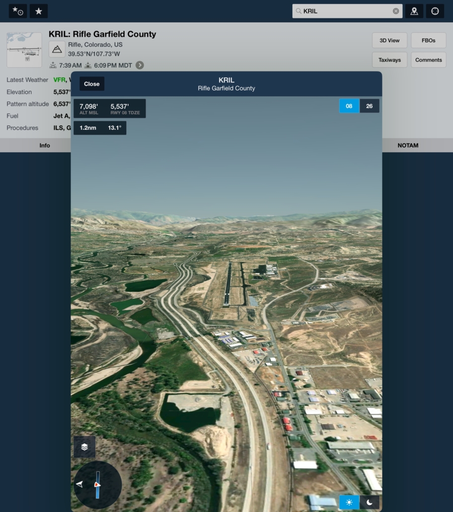
Even for IFR pilots, a Sectional Chart provides a “big picture” view of surrounding terrain and potential obstructions. As the saying goes, a picture is worth a thousand words, and a VFR chart gives you that snapshot. Today, high-resolution aerial imagery and satellite views—available via apps like Google Earth or ForeFlight—offer a realistic sense of terrain, obstacles, and land features. Combined with sectional charts, these tools help you visualize your departure path before you even leave the ground. The Sectional also hints at potential turbulence by showing your departure path’s proximity to higher terrain and how the wind is blowing across ridges. Use this opportunity to identify more hospitable terrain and consider planning your departure in that direction.
Check for Published Departure Procedures
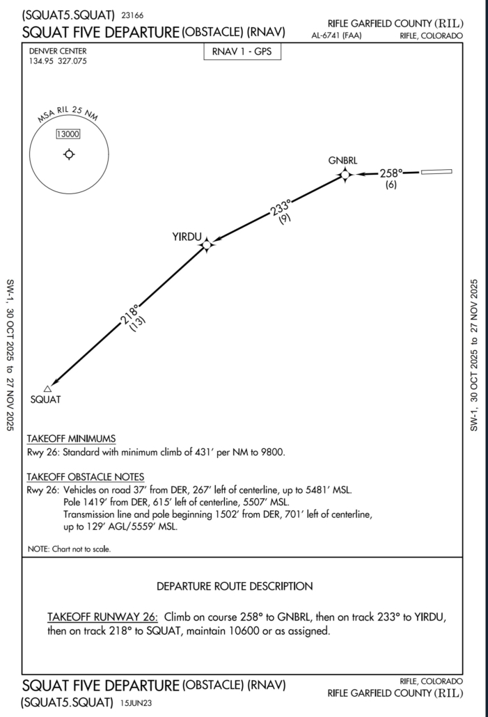 Instrument Departure Procedures (DPs) are preplanned IFR routes that provide obstacle clearance from the terminal area to the en route structure. There are two types of DPs: Obstacle Departure Procedures (ODPs) and Standard Instrument Departures (SIDs).
ODPs are developed to ensure obstacle clearance along the least restrictive route and may be printed either textually or graphically. A graphic ODP will have “(OBSTACLE)” in its title—for example, GEYSR THREE DEPARTURE (OBSTACLE) or CROWN ONE DEPARTURE (RNAV) (OBSTACLE). ODPs are recommended for obstacle clearance and may be flown without ATC clearance, provided no alternate departure (such as a SID or radar vector) has been assigned.
SIDs, on the other hand, are ATC procedures always printed graphically. They not only ensure obstacle clearance but also improve efficiency and reduce controller workload. A SID must be assigned or cleared by ATC before use. Many SIDs and ODPs today are built using RNAV criteria—these are clearly labeled with “RNAV” in the title, such as SHEAD TWO DEPARTURE (RNAV).
All DPs are designed to ensure safe transition from takeoff to the en route phase, but they assume normal aircraft performance. The minimum climb gradient is 200 feet per nautical mile (FPNM), beginning at least 35 feet above runway elevation, with no turns until reaching 400 feet unless otherwise specified. If a DP requires a steeper climb gradient, that will be published, and it’s up to you as PIC to verify your aircraft can meet it.
At some airports, ATC may provide radar vectors during climb within a Diverse Vector Area (DVA)—an area evaluated to ensure obstacle and terrain clearance in lieu of following an ODP or SID.
When an instrument approach is first designed for an airport, the need for a DP is evaluated. If an aircraft can turn in any direction after takeoff and remain clear of obstacles within the assessment area, that runway passes the diverse departure assessment and no ODP is published. If obstacles penetrate the 40:1 surface, however, the procedure designer may publish a specific route, a steeper climb gradient, or higher takeoff minimums to maintain safety.
While not mandatory for Part 91 pilots, flying a DP—especially at night, in marginal VMC, or in IMC—is strongly encouraged. ODPs are one of the simplest, most effective forms of risk management available, particularly in unfamiliar or mountainous terrain.

Planning Departures from Airports Without Published Procedures
At airports without published instrument procedures, ensure you can climb visually to a safe altitude. Use Low Altitude En Route Charts (L-charts) to determine minimum IFR altitudes for obstacle clearance. Minimum En Route Altitudes (MEAs) or Minimum Obstruction Clearance Altitudes (MOCAs) are used on published routes, while Off-Route Obstruction Clearance Altitudes (OROCAs) apply to non-published routing.
When departing an unfamiliar airport, reaching a published route at or above the MEA is generally the safest option, even if it requires a circling climb over the airport. This not only ensures obstacle clearance but also provides reliable navigation and communication coverage with ATC. Published routes often follow more forgiving terrain, giving you more options for contingencies. MOCAs provide obstacle clearance similar to MEAs but guarantee navigation coverage only within 22 nm of the VOR.
If you fly a direct, non-published route, remember that OROCAs are usually higher than published MEAs. They do not guarantee ATC communication, radar or navigation coverage, and they do not account for particularly challenging terrain.
Emergencies Following Departure
Altitudes discussed so far assume normal aircraft performance. If an emergency occurs, aim for the Minimum Safe Altitude (MSA) published on the approach chart. The MSA provides at least 1,000 feet of clearance within a specified distance from the fix upon which the procedure is based. MSAs are often divided into sectors, so confirm during preflight which sector applies based on your intended flight direction. While reviewing the approach chart, look for advisories related to terrain.

Weather Considerations
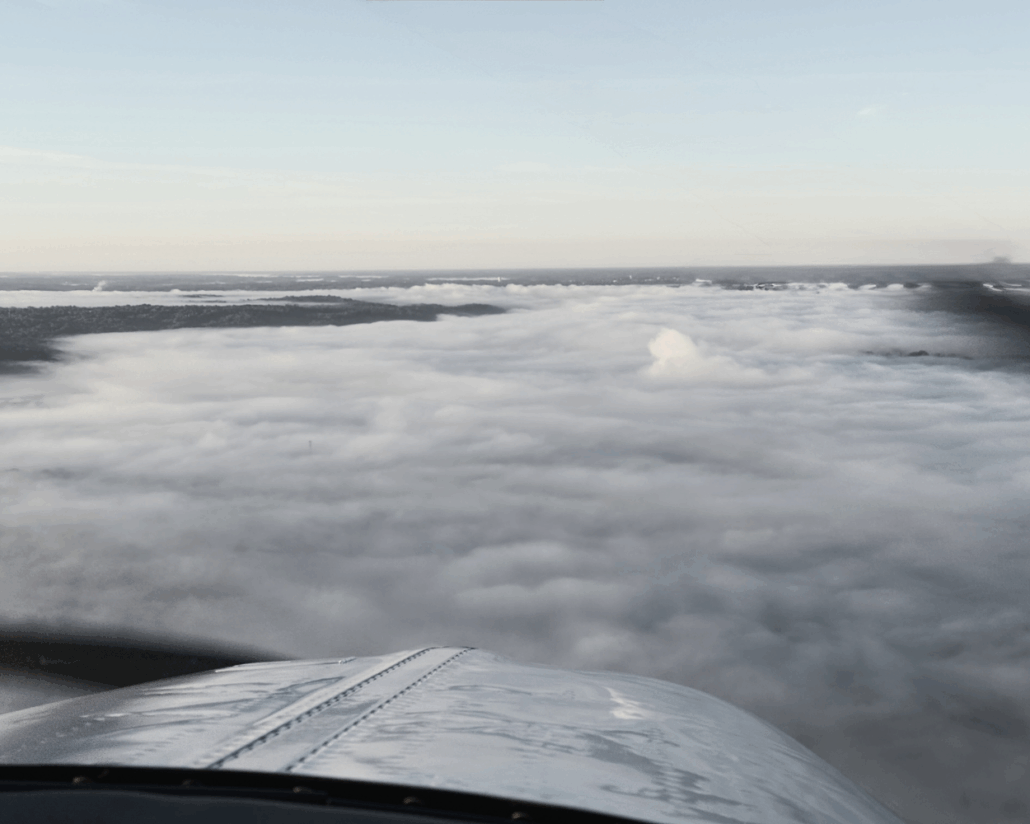
A thorough weather briefing is imperative, particularly in mountainous regions. Eastern mountains, for example, often have complex weather patterns, including IFR conditions, mountain obscurations, and slow-moving fronts. Turbulence, updrafts, and downdrafts are significant concerns near terrain. Whenever possible, remain upwind of ridges or avoid flying downwind in close proximity. Severe downdrafts can exceed aircraft climb capability; if encountered, visualize the wind pattern and turn toward lower terrain. Don’t hesitate to exercise emergency authority to leave your planned route if conditions deteriorate rapidly. Winds aloft and pilot reports can provide insight into how winds interact with ridges.
Utilize METARs, TAFs, Graphical Forecasts for Aviation, and Forecast Discussions to understand current and forecasted conditions. TAF Forecast Discussions are particularly helpful because forecasters often provide candid remarks about how the report was generated, factors considered, and their confidence in the forecast.
Clearances and Communication
Whenever possible, obtain your clearance on the ground. This reduces in-flight workload and allows you to establish airborne communication and radar contact more efficiently. If you receive a clearance in the air, ensure you can climb to an altitude that guarantees obstacle clearance and maintains communication with ATC. Plan for a published route, even if it adds extra mileage.
Technology and Terrain Awareness
Modern avionics and EFBs provide terrain awareness like never before. Moving maps, overlays, and synthetic vision make it easier to anticipate obstacles, visualize approaches and departures, and maintain situational awareness—even in reduced visibility. Using these tools, especially in mountainous areas, is invaluable for both safety and planning.
Performance, Weight, and Timing
In challenging terrain or conditions, depart as light as possible and build in extra weather margins. This enhances aircraft performance and provides alternatives if things don’t go as planned. Flying earlier in the day is usually preferable to avoid convective activity.
Local Knowledge
Finally, talk to local pilots. FBOs are often a treasure trove of insight unavailable in publications—preferred departure routes, unique ATC procedures, or helpful phrasing for obtaining clearances. Challenging departures are not the time for overconfidence—or for shying away from seeking guidance.

- New AIM Now Available, Highlights a Simple Way to Improve IFR Proficiency - July 21, 2026
- New IFR Mastery Scenario: Which Risk Will You Accept? - July 10, 2026
- New Resource Helps Demystify the Instrument Checkride—and the IPC - June 9, 2026
Leave a Reply
Want to join the discussion?Feel free to contribute!