

Behind the MVA
|
Getting your Trinity Audio player ready...
|
ATC has a minimum altitude that you won’t find on your charts, and it can explain why you can’t always get the altitude you want.
Let’s say you’re following US 95 north through the valley between Coeur d’Alene and Sandpoint, Idaho. You’re level at 4500 feet, but the weather ahead is getting worse and the mountains on either side are disappearing into the clouds. You’d rather finish the flight IFR than keep watching the valley narrow beneath a lowering ceiling. You call Spokane Approach for an IFR clearance, expecting a climb and perhaps a few vectors to get you on your way.
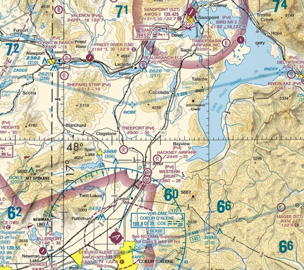
The controller asks whether you can maintain your own terrain and obstruction clearance until reaching 6900 feet.
You were kind of hoping ATC would help with that part. That was why you called in the first place. The valley floor is well below you, and you aren’t expecting to need to cross any ridges. Where did 6900 feet come from?
Knowing Your Boundaries
Spokane isn’t picking a number that sounds comfortably high, it’s coming from the Minimum Vectoring Altitude (MVA) for your current location. Much as an airway’s minimum en route altitude (MEA) establishes an altitude for flying a route, an MVA establishes an obstacle clearance altitude that allows vectors within an area. Pilots don’t ordinarily see these charts. If you’re curious, the FAA makes them available as visual references. There are also ways to load KML versions of these charts into some EFBs, but they should not be used for navigation.
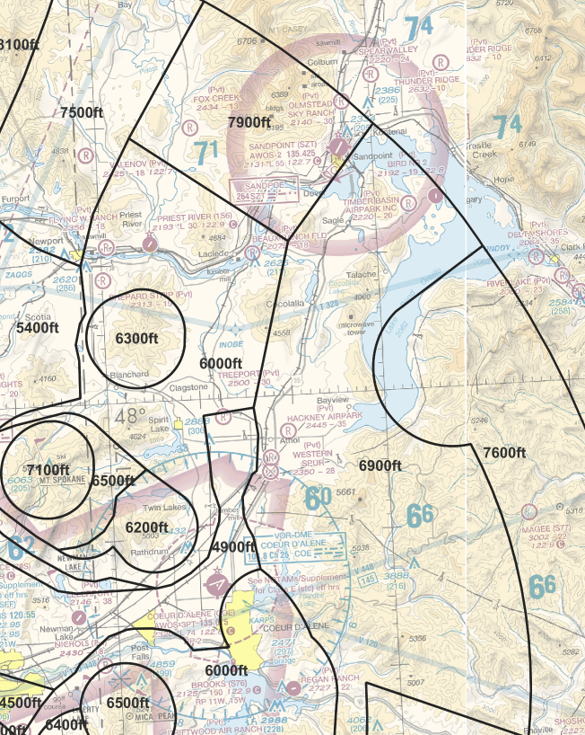
Spokane’s MVA chart divides the area into sectors, each labeled with a minimum altitude in feet MSL that applies throughout that sector. The chart shows 6000 feet over Coeur d’Alene to the south, 6900 along part of the valley, and 7900 over Sandpoint to the north. Dividing the map this way lets ATC use lower altitudes where possible rather than apply the highest minimum across the entire area. An isolated prominent obstruction can even be enclosed in its own higher area, allowing controllers to vector around it at a lower altitude (like the 6300-foot sector embedded in the 6000-foot sector).
The sector boundaries give controllers a way to work around terrain and obstacles, but they can also result in constraints for aircraft. Spokane needs you at 6900 feet to vector you within that sector. (Basically. There are some exceptions.) Continuing toward Sandpoint means eventually encountering the 7900-foot sector and the need to reach its higher minimum before crossing the boundary. If you can’t accept that climb because of icing or aircraft performance, the controller may need to issue you a different route through lower sectors or perhaps put you on airways.
The same boundaries can complicate a request for lower. If you’re already at the sector’s MVA, the controller can’t ordinarily descend you farther until reaching a lower sector. Or you might have to accept a vector toward a lower sector before starting down. That may complicate your descent planning. Or if it’s more urgent, like you’re picking up ice and need to get down right now, you’d have to up the ante to an emergency to go below MVA. As an aside: ATC can often overlay tall obstacles on their scopes for emergency vectoring below their MVA.
How High is High Enough?
As AIM 5-4-5e explains, both MVAs and MEAs normally provide 1000 feet of obstacle clearance in nonmountainous areas and 2000 feet in designated mountainous areas, although lower clearance can be authorized in mountainous areas to accommodate terminal routes or approaches. The obstacle evaluation also extends a few miles beyond the MVA sector boundary, so a ridge that sits just outside the sector can still affect the required altitude inside it.
So an MVA provides essentially the same obstacle protection as an airway MEA, but over differently defined areas. An airway segment might extend well beyond the MVA sector you’re in, while the sector might include higher terrain off to the side of the airway. The important part is that either can produce the higher minimum. So an assigned altitude below a nearby MEA doesn’t necessarily mean the controller has forgotten about the mountains.
MVA sectors also need to allow the controller to receive an adequate radar return from your airplane across the area, similar to airway MEAs also needing to ensure navigation-signal coverage along the airway. A ridge between you and the radar antenna can interfere with the return even when you’re well clear of the ground.
Centers use similar Minimum IFR Altitude (MIA) charts for off-airway vectors and direct routes, so the same general idea applies when you’re talking to an ARTCC.
Same Place, Different Altitudes
Without having onboard MVA charts available, there are still a few altitudes on your own charts that could be useful for getting a sense of safe altitudes in the area, such as when asked if you can maintain your own obstacle and terrain clearance for an IMC climb. The big numbers on the sectional and IFR en route chart look like useful candidates, but they often give you different answers over the same area.
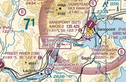
Both the Sectional’s Maximum Elevation Figure (MEF) and the IFR enroute chart’s Off Route Obstruction Clearance Altitude (OROCA) are derived from the highest terrain or obstacle underneath a block of airspace. Their altitudes account for possible errors in the elevation data and uncharted obstacles, with the resulting figures rounded up to the next hundred feet. MEFs consider a half-degree grid of latitude and longitude, whereas OROCAs consider a one-degree grid, plus 4NM beyond that grid on all sides. So a single mountain could result in a higher published figure across the whole block.
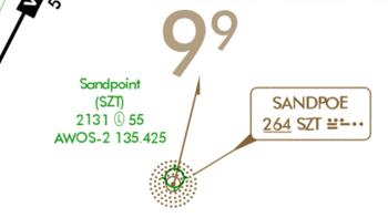 As its name suggests, the MEF simply provides the minimum elevation within the block to clear the highest obstacle, without any added clearance margin. Since the OROCA is an IFR altitude, it gets IFR obstacle-clearance applied up to four NM beyond the block. However, the OROCA isn’t assessed for navigation-signal, communications, or ATC surveillance coverage. Therefore it’s useful for flight planning and in-flight contingencies, but being above it doesn’t establish that ATC can see you, hear you, or that you can receive a VOR. Since OROCAs represent a larger grid and provide obstacle clearance, it’s typical for them to be higher than MEFs.
MEFs and OROCAs divide the chart along uniform latitude-and-longitude lines, regardless of where the mountains happen to be. MVA sectors can be tailored to the terrain, separating higher ground from areas where controllers can use lower altitudes. A mountain elsewhere in your chart grid may raise its OROCA while leaving Spokane a lower MVA over the valley.
Another Kind of Below Minimums
Back in the valley, you’re still at 4500 feet and Spokane’s minimum is 6900. That leaves 2400 feet of climb, much of it potentially in IMC. However, you don’t necessarily need to reach the MVA before receiving an IFR clearance. If you can maintain your own terrain and obstruction clearance during the climb, ATC can issue the clearance while you’re still below it. AIM 4-4-9 explains that accepting this clearance leaves you responsible for terrain and obstruction clearance until reaching the specified minimum altitude. If you can’t accept that responsibility, expect to be told to maintain VFR and figure out a Plan B.
Before accepting, what would you want to know?
Your charts can offer some perspective, but not much help with this particular climb. The sectional MEFs are 6000 and 7100 feet, without an obstacle clearance margin, while the OROCA is 9900 feet. Those figures account for higher mountains well north of your destination, but don’t tell you whether there’s room to climb through the lower terrain before reaching the MVA. A cockpit terrain display, such as TAWS or a Hazard Advisor on your EFB, can give you a more nuanced view of the nearby terrain. However, keep in mind that while the display can improve your situational awareness of the potentially unseen terrain nearby, the absence of red or yellow on the display doesn’t equate to typical IFR obstacle clearance.
Also keep in mind that there may also be a less demanding MVA nearby. Spokane’s MVA chart shows lower sectors to the west, including one at 6000 feet. While you don’t usually have that available in the cockpit, you can always just ask ATC whether a lower MVA is available nearby and what altitude would be needed there. That information could let you consider a shorter climb in a potentially friendlier area, even though you’d still need to make sure that you can get there without hitting anything.
If you’re a PilotWorkshops Premier member, you can explore how this scenario plays out in a sim using the instructions in the related Sim Challenge, “The Long Shortcut”.

- Behind the MVA - October 27, 2026
- What Lies Beneath the MDA - June 25, 2026
- Sim Challenge: Trusting the Wrong Glidepath - June 23, 2026

Leave a Reply
Want to join the discussion?Feel free to contribute!